11 September 2026 · Retained 1 June 2023 weather episode
The temperature-sampling method and the convective-history adjustment both materially affect the model’s stability diagnostic. Capturing the actual inputs separates those effects. On the supported subset, the combined preparation/sampling term is larger on average than the temperature-denominator or vertical-stencil terms. The calculation explains part of the difference identified in the earlier stability study; it does not produce a replacement wind field.
Two unchanged CALMET configurations, with terrain settings of 5 km and 10 km, were rerun with additional output recording. Both complete wind-output files are byte-identical to their retained originals. The recordings reproduce the actual stability-gradient calculation exactly at all 1,939,248 configuration–cell–hour values, covering the full 201 × 201 computational grid, both configurations and 24 intervals. The temperature passed to terrain blocking equals the current prepared temperature at the lowest, 10 m model centre.
The model normally estimates a temperature gradient between 10 m and 200 m. It interpolates the 200 m temperature from its 120 m and 230 m centres. When its incoming convective mixing height is at least 200 m, it instead assigns −0.0098 K/m. This mixing-height value carries model history. The stability expression then adds 0.01 K/m and divides by temperature, so the override leaves a small positive diagnostic rather than exact neutrality. CALMET user guide, with the exercised source path documented in the capture and interpretation review.
Across the original study area’s 244,824 cell–hour samples:
| Terrain setting | Samples using the convective override | Samples available for the complete common-height comparison |
|---|---|---|
| 5 km | 136,940 | 38,935 |
| 10 km | 136,892 | 38,935 |
Prepared temperature profiles are identical between configurations. Their override decisions differ at 56 original-area cell–hour samples, all outside the complete comparison subset. Thus the two configurations have identical results on that subset; this does not make their full wind fields equivalent. Of the 38,935 supported samples, 21,158 use the override in either configuration.
The alternative diagnostic samples the archived native profiles at four common absolute heights: fine-grid terrain plus 10, 120, 200 and 230 m. Each sample uses the model’s four actual neighbouring native columns and its retained interpolation weights. Every neighbour must bracket every requested height. No missing column is substituted and no temperature is extrapolated below the first native level.
The source prepares temperatures above each native column’s own ground before combining columns. Its preparation can also include below-first-level day/night extrapolation and thermal history. Consequently, a difference from common absolute-height sampling combines several effects; it is not solely a terrain error or a measured temperature bias.
The decomposition starts with the captured stability proxy, A = 9.8 × (GAMMA + 0.01) / TEMP2D, and ends with the common-height 10–200 m temperature-gradient diagnostic. The four differences below follow the declared order; they are an algebraic decomposition, not a unique separation of physical causes:
| Component | What changes | Mean absolute contribution, s⁻² |
|---|---|---|
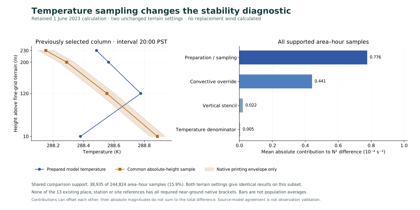
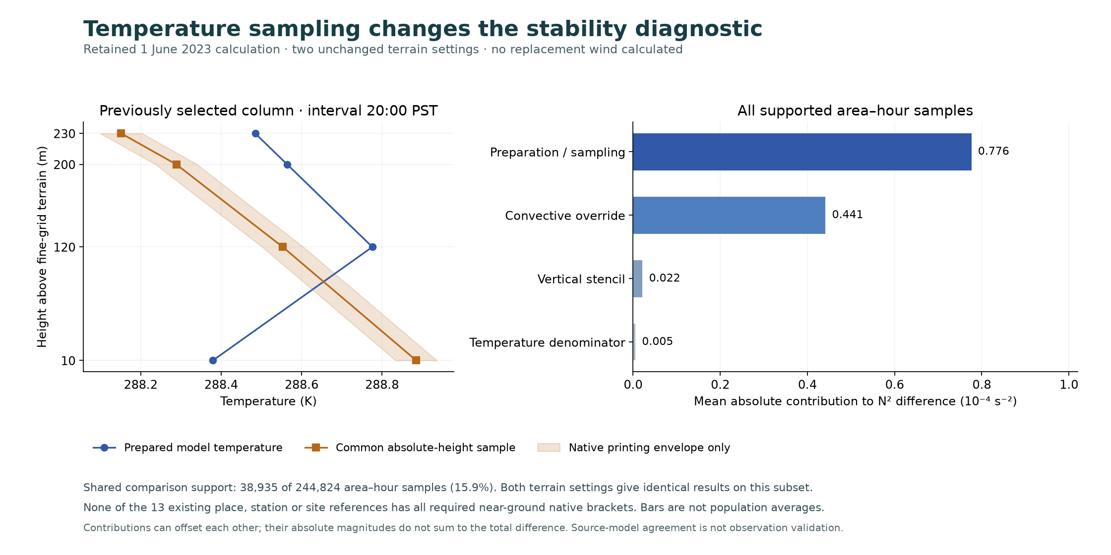
| Convective override | Replace the assigned gradient with the ordinary gradient reconstructed from captured temperatures | 4.414 × 10⁻⁵ |
| Preparation and sampling | Replace prepared temperatures with common absolute-height samples, retaining the 120/230 m interpolation and captured denominator | 7.763 × 10⁻⁵ |
| Temperature denominator | Use the common-height 10 m temperature in the denominator | 5.308 × 10⁻⁷ |
| Vertical stencil | Sample 200 m directly rather than interpolating between 120 and 230 m | 2.160 × 10⁻⁶ |
All components use exactly the same 38,935 samples. Their signs can offset: the mean absolute total difference is 5.645 × 10⁻⁵ s⁻², and the component magnitudes must not be added as an error budget. Neither diagnostic is an independent observation. The source-order reconstruction retains single-precision arithmetic; the decomposition is evaluated in double precision.
Vector figure. The left panel uses the column and hour selected in earlier work, not a newly selected extreme. The right panel covers the complete supported subset, identically for both settings.
At that previously selected column, row 101/column 130, interval starting 20:00 fixed PST, the convective override is inactive. The captured proxy is 3.729 × 10⁻⁴ s⁻²; the direct common-height diagnostic is 2.327 × 10⁻⁴ s⁻². Most of their 1.402 × 10⁻⁴ s⁻² difference comes from the combined preparation/sampling term. The override contributes zero to this sample’s current proxy difference. This does not isolate prior history, neighbouring cells or every native preprocessing step, and does not resolve the earlier large vertical-wind discrepancy.
The complete four-height comparison is available for 15.9% of the original area–hour samples. Support at individual heights is 38,935 samples at 10 m, 91,198 at 120 m, 130,972 at 200 m and 143,033 at 230 m. The lowest-height requirement controls the complete subset.
None of the 13 existing place, station or site references has complete four-neighbour support at all four heights in any of these 24 intervals. Their captured source values and missing comparison values are retained in the tables. The subset statistics must not be generalized to those communities. Missing brackets reflect terrain differences and the native model’s lowest atmospheric level; they do not imply absent wind or absent exposure. The references themselves are not an exhaustive population-receptor inventory.
Temperature printing envelopes vary each native bracket’s endpoint temperatures by ±0.05 K and heights by ±0.5 m, evaluating all 16 corners. They cover printing alone, at a fixed bracket. Of the complete samples, 9,707 have at least one target within 0.5 m of a native level and are marked bracket-ambiguous. Nominal results remain in the descriptive tables; no robust derived-stability sign or confidence interval is claimed. Model error, humidity effects, unresolved inversions and height-datum approximations remain outside these envelopes.
The captured ordinary-gradient and override paths are now reproducible. Further work should test whether the chosen atmospheric representation is suitable for local transport, with the same criteria across communities. A numerical change that merely reduces a large wind value would not establish that suitability.
The separate higher-precision archive recovery supplies unrounded temperature, pressure, humidity and height for a previously selected 100-column tile. It enables a precision sensitivity check there; it does not supply finer physical resolution or community-wide near-ground coverage. Independent local wind and temperature profiles remain a priority, alongside the existing source, shoreline and airport comparisons. Current flare emissions, heat, geometry, plume rise and breathing-height receptors are separate requirements for exposure prediction.
This study has not changed the public Explorer’s wind forcing or concentration estimates.
Declared protocol, summary, all reference series, previously selected column and neighbours, all interval summaries, and calculation checks.
Independent parsing and calculation reproduce all 39 compared arrays, 48 interval rows and 864 reference/stencil rows. The largest temperature-array difference is 1.14 × 10⁻¹³ K; the largest derived stability difference is 2.11 × 10⁻¹⁷ s⁻², consistent with the documented order of floating-point operations. The root calculation closes the four-component identity to 5.42 × 10⁻²⁰ s⁻² and exactly matches the preceding captured gradient and temperature fields. An initial independent timestamp check compared different endpoint encodings; decoded dates agree, and the original failed check and correction are retained. Independent reconstruction checks, full comparison. The two unchanged model replays, raw captures, full arrays and source patch are retained locally with hashes. These implementation checks establish calculation consistency, not atmospheric validation.